
Nestled among the towns of Bella, Atella, Ruoti and Avigliano, the Ares wind farm is located 15 km north-west to Potenza, in an area that is primarily dedicated to livestock grazing and, to a lower extent, agriculture.
The area is marked by a pretty rugged mountain range, made up of the high peaks of Mount Caruso and the gentler ones of Toppe di Atella. The plant is located at an average height of 1,000 m asl, covering both the peaks and the mountainsides.
The hydrographic system is characterised by the Tiera and Basento rivers to the north and north-east, the Marmo-Platano river to the west (a tributary of the Tanagro river) and the Atella river to the north-west.
The hills and rivers have had an impact on the way men have settled throughout the area since ancient times. The peculiar orographic features of the land, which is quite rugged but accessible, have enabled to build a rather articulated road system, with short and medium-range itineraries that have favoured its continued habitation. The local road system is made up of a dense network of sheep tracks, with passes connecting to the surrounding river valleys.
From an archaeological point of view, the plant project area is part of an ancient district of Lucania (historical region of Southern Italy, currently known as Basilicata), known in archaeological literature as the “northern Lucanian area”. The earliest known evidence of human presence in the area dates back to the Neolithic, when some groups dedicated to agriculture and farming settled on the high ground of Montocchio, near Potenza. Further evidence dating back to the Protohistoric period can be found on the high ground of Barrata, in the area of San Giovanni di Ruoti, San Cataldo and Sant’Antonio Casalini of Bella. In ancient times, various hills, placed in a strategic position to control the river valleys, saw a demographic boom.
Despite the particularly arduous nature of some sectors, the area is crossed by several roads that play a pivotal role for the plant’s infrastructure: some tracks and municipal roads will be used during the plant’s construction and operation, thus minimising the need to build new roads.The area surrounding the wind power plant is dotted with large farms and small urban centres, including the towns of Sant’Ilario in the north and San Cataldo in the south.
Sant’Ilario in the municipality of Atella, s a small village perched at 870 m asl on a spur of the Apennines, which from Mount Caruso (1236 m) gently slope down towards Vitalba valley (450 m). Clinging to the side of the rock, close to the ancient sheep track “Potenza-Venosa”, the village gently opens up to the east, overlooked by the impressive Lagopesole Castle. Today, Sant’Ilario is being rediscovered as a tourist destination, both in summer and winter, thanks to a welcoming hotel that has created to host students, visitors and tourists.

Sant’Ilario (foto Fabio Cocchia / Fotografando Basilicata)
San Cataldo is a hamlet found in the Municipality of Bella. The Bagni area is famous for the presence of sulphurous water, suitable for thermal baths, whereas the Caldane district is known for its mineral spring waters containing salts of iron.
The waters of San Cataldo thermal baths have been known since the early 1800s. For many years they were only visited by the locals, who had discovered the important beneficial properties of mineral sulphurous waters. Visitors to San Cataldo thermal baths can enjoy the energy of its well-preserved natural landscape and improve their physical and mental wellbeing.
The “Bread Trail” (Sentiero del Pane), which takes place on 13th August, offers visitors the chance to walk along a path that joins together the main bakeries of the hamlet to taste their delicious typical products. Along the trail, various exhibitions on the cycle of wheat, the ancient tools used by peasants in their daily life and the making of bread take place, which are enlivened by popular music concerts and shows by artists and musicians.
-

- Thermal baths of San Cataldo
-

- An ancient oven in the hamlet of San Cataldo

The Sanctuary of the Madonna del Carmine in Avigliano really stands out for its monumental and religious value. It is located on the top of Mount Carmine, a 1,227 high peak belonging to the Lucanian Apennines. According to the tradition, the cult of the Madonna del Carmine (Virgin of the Carmine) became popular in Avigliano earlier than in other areas of the region, thanks to the devotion of the Crusaders returning from the East.The first evidence to the presence of a rudimentary hut, depicting an image of the Madonna standing on the top of a 1,227 m mountain (“montagnola”, meaning “little mountain” in Italian) dates back to the 12th century.
In 1694 a terrible famine, followed by a violent earthquake, struck the population. Some citizens, who were standing in Piazza Gianturco in the town of Avigliano, swore that they saw the Castle and the bell tower bend, as if they were collapsing, and then immediately stop in their original position, without any fracture. The population then took refuge on the “montagnola” for forty days, during which they made a vow: if they returned safely to their homes, they would proclaim the Madonna del Carmine as patron saint of Avigliano. They would also buy a wooden statue and build a chapel in that very place. There was no loss among the locals and no houses were damaged, despite the violent earthquake and the frequent tremors. They attributed the miracle to the Virgin’s protection. So, in 1696, they immediately bought the statue (the one that is still venerated today) at the Neapolitan art school of the time.
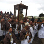
The statue represents the Virgin standing and holding the Child, who leans towards and almost embrace her. They also decided to build a chapel on the mountain, which was renamed Mount Carmine. From then on, every 16th July, a festival dedicated to the Virgin has been celebrated (the celebration was made official in 1811). On 16th July, the statue of the Virgin is carried in procession to the Church of Santa Maria degli Angeli. From here, a pilgrimage to the Sanctuary begins, along a 6-km trail. During the procession, small structures of votive candles known as “cinti” are carried as a sign of devotion, together with the “palii”, which are triangular linen signs with a gold embroidered image of the Madonna onto them. Once the procession has arrived at the mountain, it makes three laps around the church and then the Holy Mass is celebrated. At the end, the believers have lunch outdoors. The popular devotion to the “Madonn du Mont” (dialect for “Virgin of the Mount”) is very much alive in all the villages of the district, so as to attract thousands of pilgrims on both annual celebrations.
-

- Sanctuary of Madonna del Carmine

-

- Sanctuary of Madonna del Carmine

-

- Sanctuary of Madonna del Carmine, procession

-
- Sanctuary of Madonna del Carmine, procession
